Transforming our world
through nonviolent action
through nonviolent action
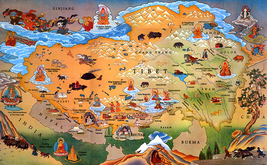
SIZE: 2.5 million sq. km.
CAPITAL: Lhasa
POPULATION: 6 million Tibetans and an estimated 7.5 million Chinese, most of whom are in Kham and Amdo
LANGUAGE: Tibetan (of the Tibeto-Burmese language family).
PROVINCES: Amdo, Kham & U-Tsang
BORDERING COUNTRIES: India, Nepal, Bhutan, Burma, China
NATIONAL FLAG: Snow lions with red and blue rays. Banned in Tibet
RELIGIOUS LEADER: The 14th Dalai Lama
POLITICAL LEADER:Sikyong (Prime Minister) Penpa Tsering"
GOVERNMENT IN EXILE: Parliament (Central Tibetan Administration)
GOVERNMENT IN TIBET: Communist (People’s Republic of China)
RELATIONSHIP WITH THE PRC: Colonial
LEGAL STATUS: Occupied
ECONOMY: Tibetans: predominantly in agriculture and animal husbandry. Chinese: predominantly in government, commerce, and the service sector.
AVERAGE ALTITUDE: 14,000-16,000 ft.
HIGHEST MOUNTAIN: Chomo Langma (Mt. Everest) 29,028 ft
AVERAGE RAINFALL: Varies widely. In the west it is 1mm in Jan. to 25mm in July. In the east, it is 25-50mm in Jan. and 800mm in July
AVERAGE TEMPERATURE: July 58°F (14.5°C); Jan. 24°F (-4.5°C).
MINERAL DEPOSITS: Borax, uranium, iron, chromite, gold
MAJOR RIVERS: Mekong, Yangtse, Salween, Tsangpo, Yellow, Indus, Ganges, Irrawaddy
MAJOR ENVIRONMENTAL ISSUES: Rampant deforestation in Eastern Tibet, poaching of large mammals, grassland desertification, permafrost degradation, unregulated and destructive mining and resource extraction
STAPLE FOOD: Tsampa (roasted barley flour)
NATIONAL DRINK: Salted butter tea
ANIMALS: Wild yak, Bharal (blue) sheep, Musk deer, Tibetan antelope, Tibetan gazelle, Kyang (wild ass), Pica
BIRDS: Black necked crane, Lammergeier, Great crested grebe, Bar-headed goose, Ruddy shel duck, Ibis-bill